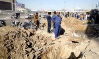
KARACHI/HYDERABAD: Intermittent heavy showers and strong winds battered Karachi on Tuesday, partially flooding roads and cooling the city’s sweltering weather, as a well-marked low-pressure system over India’s Gujarat coast edged closer to the Arabian Sea, raising the risk of a tropical cyclone later this week.
Moderate to heavy rain was recorded in several neighbourhoods, including Liaquatabad, Federal B Area, Saddar, II Chundrigar Road, Korangi and Sharea Faisal, while winds of up to 45 kilometres per hour were observed in different parts of the city.
According to the Pakistan Meteorological Department (PMD), DHA Phase VII recorded 26.8mm of rainfall by Tuesday evening, while PAF Faisal Base received 29mm. The old airport area measured 33.7mm, Jinnah Terminal 20.8mm, Korangi 20.5mm, and Gulshan-e-Hadeed 25mm.
Other stations reported lower but significant figures, including University Road 8.4mm, Keamari 7.5mm, Bahria Town 20.5mm, Gulshan-e-Maymar trace, and Nazimabad 1.4mm. In parts of DHA and Clifton, water accumulated on roads, causing partial urban flooding and traffic disruptions.
The PMD said moist currents from the Arabian Sea are driving widespread rain and thunderstorms across southeastern Sindh, affecting Karachi, Hyderabad, Thatta, Badin, Sujawal, Tharparkar, Umerkot, Mirpurkhas, Sanghar and adjoining districts from September 29 until October 2. Isolated heavy falls are expected in Tharparkar, Umerkot and Mirpurkhas.
According to the Tropical Cyclone Warning Centre in Karachi, the low-pressure system was lying over Saurashtra, Gujarat, around 340 kilometres southeast of Karachi on Tuesday morning.
It is likely to move west-southwest and emerge into the Arabian Sea by late Tuesday night or Wednesday morning. Meteorologists said favourable conditions, including warm sea surface temperatures and upper-level divergence, could cause it to intensify into a depression and possibly develop into a cyclone in the coming days.
Officials clarified that there is no immediate threat to Pakistan’s coastal belt. However, they warned that the sea will remain rough to very rough with squally winds between 45 and 55 kilometres per hour. Fishermen have been strictly advised not to venture into deep waters until October 2.
Provincial disaster management authorities have instructed Deputy Commissioners and District Disaster Management Authorities (DDMAs) across Sindh to stay on round-the-clock alert and prepare mitigation measures in case of emergencies.
The Met Office forecast cloudy weather in Karachi over the next 24 hours, with chances of light to moderate rain and drizzle at scattered places. The maximum temperature is expected to range between 35 and 37 degrees Celsius, while humidity stands at around 65 percent. Winds are expected to continue from the southeast.
Authorities also warned that strong winds and lightning could damage weak structures, power poles, billboards and solar panels in vulnerable areas. Meanwhile, the Kotri Barrage was reported in medium-level flood on Tuesday morning with an inflow of 335,567 cusecs, while Guddu and Sukkur barrages recorded normal flows.
Earlier this month, Karachi endured heavy rains from September 8 to 10 that submerged large swathes of the metropolis, left rivers overflowing and forced hundreds of residents to remain stranded for hours. Another spell of drizzle followed on September 16. Tuesday’s fresh showers again provided relief from the lingering heat but revived concerns of further flooding if the system over the Arabian Sea strengthens into a cyclone in the days ahead.
KE’s safety protocol
K-Electric (KE) urged citizens to prioritise safety and remain vigilant, particularly in areas where waterlogging becomes an issue, as moderate to heavy showers broke the spell of heat in the city on Tuesday.
KE field teams remained on alert to monitor the situation and address any localised issues. The network remained stable and at the peak of the downpour, less than 175 of KE’s 2,100-plus feeders saw a temporary outage mainly due to safety reasons. These feeders were also quickly restored as rain stopped and safety clearances were received from the field teams.
“Our foremost priority remains public and our staff’s safety,” said Imran Rana, KE spokesperson. “While our systems have remained stable, we urge citizens to adhere to safety protocols.”
KE emphasises that public safety remains its foremost priority. Citizens are strongly advised to maintain safe distance from poles, meters, and service brackets. Avoid contact with broken or tangled internet and tv cables, including communication wires. Refrain from using illegal connections, encroachment or makeshift arrangements in flooded conditions.
Lower Sindh
Scattered thunderstorms accompanied by strong winds and rainfall lashed Hyderabad and various districts of lower Sindh over the past 24 hours, disrupting normal life and electricity supply.
According to the Meteorological Department, Hyderabad received 23.2mm of rainfall, Mirpurkhas 27mm, while Shaheed Benazirabad district recorded 41mm in Sakrand and 29mm in Padidan.
In Hyderabad, heavy showers led to waterlogging on roads in City, Latifabad, and Qasimabad areas. Most power feeders tripped, causing outages across several localities, though supply was later restored.
A Hesco spokesperson said that due to strong winds and heavy downpour, 147 feeders of 11KV tripped in the Hesco region, including 65 feeders in Hyderabad city alone. The outages also affected areas connected to grid stations in Matiari, Hala, Saeedabad, Sakrand, Qazi Ahmed, Nawabshah, Daur, Doulatpur, Shahdadpur, Tando Adam, Kandiari, and Sanghar.
The Meteorological Department has forecast that the current spell of rain is likely to continue until October 3.